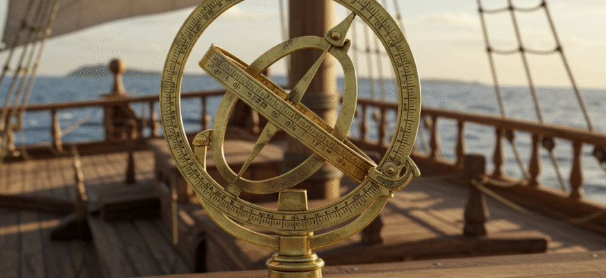
Imagine the vast, unforgiving ocean. No land in sight for weeks, perhaps months. Your ship, a tiny speck on an immense blue canvas, is your entire world. How did those early mariners, the intrepid souls of the Age of Discovery, even begin to guess where they were or in which direction to steer? While charts and compasses played their parts, one deceptively simple instrument became a cornerstone of celestial navigation: the mariner’s astrolabe. It was not a magical device, but a robust, practical tool forged from necessity.
What Was the Mariner’s Astrolabe?
The mariner’s astrolabe was a stripped-down version of its more complex cousin, the planispheric astrolabe. While the latter was a multifaceted astronomical calculator, capable of solving many problems related to time and the position of celestial bodies, it was far too delicate and intricate for the rough and tumble environment of a ship’s deck. The mariner’s astrolabe, by contrast, was built for one primary job: to measure the altitude, or height, of the sun or a star above the horizon.
Typically fashioned from brass or bronze to resist corrosion from salty sea air, it was essentially a heavy, graduated ring or disc. This weight was crucial, helping it hang vertically and remain relatively stable despite the ship’s pitching and rolling. Pivoting at the center of this ring was an alidade, a sighting rule with two pinnules or vanes, each pierced with a small hole. The outer edge of the ring was marked in degrees, usually from 0 to 90 in each quadrant, though some simpler versions might only have one 90-degree arc.
Its design philosophy was all about utility over intricacy. There were no delicate moving plates or complex star charts engraved upon its surface. It was a tool, pure and simple, designed to be used by practical seamen who needed reliable, if not perfectly precise, information.
How Did It Work at Sea?
Using the mariner’s astrolabe required a steady hand and a bit of practice, especially on a heaving deck. The navigator would hold the instrument by its suspension ring, letting it hang freely. Then, they would align the alidade with the celestial body of interest.
For the sun, caution was paramount. Navigators would typically not look directly at the sun through the pinnules. Instead, they would adjust the alidade until the ray of sunlight passing through the upper pinnule’s hole fell precisely onto the hole of the lower pinnule. The point where the alidade crossed the graduated scale on the ring then indicated the sun’s altitude in degrees. This measurement was most often taken at noon, when the sun reached its highest point in the sky for that day. This “noon sight” was critical for determining latitude.
At night, a prominent star like Polaris (the North Star) or another star of known declination could be used. In this case, the navigator would look through the pinnules, aligning them with the star. The reading was then taken in the same way.
The Challenge of a Moving Deck
The difficulty of this task should not be understated. A ship at sea is rarely still. It rolls from side to side, pitches bow to stern, and yaws with the wind and waves. Holding the astrolabe steady enough to get an accurate reading was a significant challenge. Experienced mariners developed techniques to compensate. They might take multiple readings and average them, or work in pairs, with one person holding the instrument and another taking the sighting. Some astrolabes were made quite heavy, with some surviving examples weighing several kilograms, precisely to dampen the effects of the ship’s motion.
A Child of Necessity: Its Origins and Use
The precise origins of the mariner’s astrolabe are somewhat debated, but its development is closely linked to the surge in oceanic exploration undertaken by the Portuguese in the 15th century. As voyages pushed further south along the African coast and then out into the Atlantic, navigators needed reliable methods to determine their latitude far from familiar shores. Traditional coastal piloting techniques were useless in the open ocean.
It likely evolved from the astronomical astrolabe, simplified and made more rugged for sea conditions. By the late 15th and early 16th centuries, during the great voyages of figures like Vasco da Gama and Christopher Columbus (though Columbus primarily relied on dead reckoning and quadrants), the mariner’s astrolabe became an indispensable tool. It allowed ships to sail east or west along a specific line of latitude, a crucial strategy for reaching a known destination or exploring new territories.
The mariner’s astrolabe was a pivotal advancement for oceanic navigation. Its robust design and focused functionality enabled mariners to determine latitude with greater confidence than ever before. This was essential for the extensive voyages of the Age of Discovery, transforming seafaring from coastal hopping to transoceanic exploration.
Strengths and Inevitable Limitations
The mariner’s astrolabe’s greatest strengths were its simplicity, robustness, and relative ease of use compared to more complex instruments. Made of metal, it could withstand harsh weather and the occasional knock. It did not require intricate knowledge of astronomy to operate, only the ability to take a sight and read a scale, coupled with the use of declination tables.
However, it was far from perfect. Its accuracy was inherently limited, especially on a small, lively ship. Even with a heavy instrument, errors of a degree or more were common. A one-degree error in latitude translates to 60 nautical miles, a significant distance. Furthermore, it could only measure altitude; it could not directly help with longitude, the other crucial coordinate for fixing a position. Determining longitude at sea remained a fiendishly difficult problem until the invention of the marine chronometer in the 18th century.
Dealing with Declination
To calculate latitude from the sun’s noon altitude, navigators needed one more piece of information: the sun’s declination for that day. Declination is the angular distance of the sun north or south of the celestial equator. This value changes throughout the year as the Earth orbits the sun. Navigators carried tables, or ephemerides, which listed the sun’s declination for each day. With the measured noon altitude and the day’s declination, a simple calculation (addition or subtraction, depending on the hemisphere and time of year) would yield the ship’s latitude.
Beyond the Astrolabe: The March of Navigational Technology
While the mariner’s astrolabe was a workhorse for a significant period, the quest for greater accuracy spurred further innovation. The quadrant, another instrument for measuring angles, was also used, sometimes preferred by navigators like Columbus for its potentially greater stability in certain conditions, though it often required two people to use effectively for solar observations.
Later, the cross-staff appeared, allowing navigators to measure altitude without looking directly at the sun, by observing its shadow. This was an improvement, but it too had its challenges. The backstaff (or Davis quadrant), invented around 1594, was a significant step forward. It allowed the user to observe the sun’s shadow while simultaneously aligning the horizon, offering better accuracy.
Ultimately, the invention of the octant in the 1730s, and then the more refined sextant, with their mirrored optics and vernier scales for precise readings, rendered the mariner’s astrolabe obsolete. These instruments offered far superior accuracy and ease of use, becoming the new standard for celestial navigation well into the 20th century.
Yet, the mariner’s astrolabe holds an undeniable place in history. It was a bridge, a vital tool that enabled the daring voyages that redrew the map of the world. Its heavy, simple form speaks of an era when courage and rudimentary science combined to conquer the vastness of the oceans.