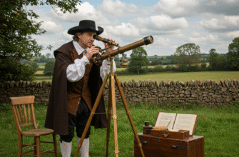
Long before the advent of theodolites, GPS, or even sophisticated maps, ancient civilizations faced a fundamental challenge: how to define, divide, and demarcate land. Whether for agriculture, settlement, or sacred spaces, establishing boundaries was crucial. In a world without our modern tools, early surveyors and community leaders turned to one of the most consistent and awe-inspiring resources available – the night sky. The predictable dance of stars and constellations offered a grand celestial blueprint, a divine map that could be mirrored on Earth.
The Unchanging Canvas Above
Imagine standing in an open field, night after night, year after year. While the seasons changed the landscape around you, the patterns in the sky – the constellations – returned with remarkable regularity. This perceived stability of the celestial sphere, with its slowly wheeling stars, provided a fixed reference system unlike anything on the terrestrial plane, which was subject to floods, erosion, or human alteration. The North Star, or Polaris, for cultures in the Northern Hemisphere, became an obvious anchor point, a steadfast beacon around which the other stars appeared to revolve. Identifying true north was the first, essential step in orienting oneself and, by extension, orienting a parcel of land.
But it wasn’t just about a single point. The entire sweep of the heavens offered guidance. The rising and setting points of prominent stars and constellations along the horizon provided a series of natural markers throughout the year. These weren’t just random points of light; they formed part of a cosmic clock and calendar, vital for societies whose lives were intimately tied to agricultural cycles and seasonal changes.
Reading the Starry Signposts
While the concept of a single “North Star” is relatively straightforward for establishing a cardinal direction, entire constellations or distinctive groups of stars (asterisms) served as broader indicators. For instance, the path of a specific, easily recognizable constellation as it traversed the sky could be used to project a line on the ground. The “belt” of Orion, the distinctive ‘W’ of Cassiopeia, or the bright stars of the Pleiades cluster, due to their recognizability, could have been instrumental. Observers would note their position at rising, culmination (highest point), or setting relative to local landmarks.
These stellar alignments were not just about north-south lines. East-west orientations could be determined by observing the celestial equator’s projection or the rising and setting points of stars known to be near it. Different cultures would have identified their own significant star patterns, embedding them within their cosmologies and practical knowledge systems. The key was consistency: if a boundary stone was placed in alignment with a particular star rising over a distant mountain peak at a specific time of year, that alignment could be checked and re-established if necessary.
Ancient peoples across various cultures demonstrated a profound understanding of celestial mechanics. They meticulously observed the regular movements of stars and planets, using this knowledge not only for timekeeping and navigation but also for orienting structures and potentially marking territorial boundaries. This astronomical prowess was a cornerstone of many early civilizations’ practical and spiritual lives.
Aligning Earth with Sky
The application of celestial knowledge to land division often involved more than just general directions. Specific alignments held significance. Key moments in the solar year, such as the solstices (longest and shortest days) and equinoxes (equal day and night), were marked by the Sun’s rising and setting positions on the horizon. These solar markers could, in turn, be correlated with the positions of certain constellations visible at those times.
Imagine a community needing to establish the boundaries of a communal farming plot. They might wait for the summer solstice, note where the sun rises, and then, using that alignment, perhaps project lines inland. Or, they might use a star that rises heliacally (just before the sun) around the time of planting or harvest. This star’s rising point could then become a reference for laying out fields or marking property limits. The orientation of ceremonial pathways, temples, or even entire settlements has been shown in many archaeological contexts to correspond with significant celestial events. It’s a logical extension to believe that similar principles were applied to the more mundane but equally vital task of land surveying.
Seasonal Markers and Practical Application
The agricultural calendar was deeply intertwined with celestial observations. The appearance of certain constellations in the evening sky signaled times for planting, harvesting, or preparing for seasonal changes. It is highly plausible that the divisions of land related to these activities would also incorporate celestial alignments. For example, if a particular constellation became prominent when it was time to flood irrigation channels, the main channels themselves might be oriented according to a star within that group. This created a harmonious system where the rhythms of the sky directly informed the layout and management of the land. This wasn’t just abstract astronomy; it was applied science born of necessity.
Navigating the Difficulties
Utilizing constellations for land surveying was an ingenious solution for its time, but it was not without its challenges. The precision achievable would, of course, be far less than what modern instruments offer. Accuracy depended heavily on the skill of the observer, the clarity of the night sky, and the stability of any sighting aids used, such as sighting stones or simple gnomons.
Weather conditions were a significant variable. Cloudy nights could render the celestial map useless, delaying or disrupting surveying activities. Furthermore, the Earth’s axial precession, a slow wobble in its rotational axis, causes the apparent positions of stars to shift gradually over centuries. While this effect is minor year-to-year, over generations, alignments established with specific stars would slowly become inaccurate. Ancient surveyors might have accounted for this through recalibration or by focusing on more stable, short-term observations, but it remains a factor in interpreting very old alignments.
Another challenge lay in translating a curved celestial sphere onto a localized, often uneven, terrestrial surface. While sighting along a star’s path could define a line, determining precise angles or extensive gridded areas would have required sophisticated geometric understanding, which, while present in some cultures, was not universally advanced to the levels needed for highly accurate large-scale cadastral mapping by stellar means alone.
Clues Etched in Stone and Story
Direct, explicit records detailing “how-to” survey land using stars from many ancient cultures are scarce. Much of what we infer comes from a combination of archaeological evidence and an understanding of their astronomical knowledge. The orientation of megalithic sites like Stonehenge, the pyramids of Giza, or ancient city grids often reveals alignments with solstitial sunrises/sunsets or the rising/setting points of prominent stars like Sirius or those in Orion.
While many of these structures had ceremonial or religious significance, the underlying principles of astronomical alignment could easily have been adapted for more utilitarian purposes such as land division. If a temple could be precisely oriented to a celestial event, so too could a field boundary or a property line. The challenge for modern researchers is distinguishing between intentional, precise surveying and coincidental or symbolic alignments. However, the repeated patterns of celestial orientation across diverse cultures and geographical locations strongly suggest a widespread practical application.
Ethno-astronomical studies of more recent indigenous cultures also provide clues, revealing how traditional societies continued to use celestial knowledge for navigation and understanding their environment, sometimes including principles applicable to territorial understanding, even if not formal surveying in the modern sense.
A Universe of Understanding
The use of constellations in land surveying was not an isolated skill but part of a broader, integrated understanding of the cosmos. Ancient astronomers were also often the timekeepers, the calendar makers, and the navigators. The same stars that guided ships across open waters or caravans across featureless deserts could delineate a plot of fertile land along a riverbank. This holistic approach, where astronomy, agriculture, religion, and daily life were deeply interwoven, characterized many ancient societies.
Their worldview often did not separate the celestial from the terrestrial in the way modern science tends to. The sky was an extension of their environment, a source of guidance, meaning, and practical information. Therefore, using its patterns to organize their earthly affairs, including the fundamental act of apportioning land, was a natural and logical step. This knowledge was likely passed down through generations, refined by observation, and encoded in stories, rituals, and the very layout of their communities.
Echoes of Celestial Order
In the grand tapestry of human ingenuity, the methods ancient peoples devised to understand and organize their world are truly remarkable. Lacking the sophisticated tools we rely on today, they looked to the heavens, finding in the silent, wheeling constellations a reliable guide for earthly matters. The use of stars for land surveying and boundary marking, while perhaps not always achieving the precision of modern methods, speaks volumes about their observational skills, their deep connection with the natural world, and their ability to translate cosmic order into terrestrial structure. It’s a testament to the enduring human need to create order and define place, using the grandest of all available canvases – the night sky itself – as their ultimate reference.
The legacy of this ancient practice is subtle, often buried beneath layers of subsequent development or lost to the mists of unrecorded history. Yet, every time we look up at a familiar constellation, we are, in a sense, connecting with those early surveyors who saw in those same patterns not just mythological figures, but practical tools for shaping their world and laying the foundations for settled life.